Maps are a classic of the fantasy genre, painting an entire world in broad strokes that your imagination might fill in the rest. They’re popular in tabletop games and are in the rare category of GM tools that save you time, further immersion in the game, and provide clear story and gameplay advantages. While it’s easy to over-invest in a map, eating into the time and energy you have for other parts of the game, they’re an incredible asset if you choose to make them. While the advice here focuses on wilderness campaigns rather than urban areas, most of it is cross-applicable.
The goal of a map is threefold: to facilitate the mechanics of travel, to illustrate the world your game is taking place in, and to provide choices for your players and characters.
As the standard function of a map, making a map that facilitates travel is intuitive. For ease of use, you want to delineate terrain that will change travel times and make sure that your scale plays well with the game’s overland travel rules. Hex maps are popular for exploration-heavy campaigns precisely because they provide clear guidelines for what areas contain what terrain, and they provide an easy way to measure how far a party can move, allowing for easier implementation of travel mechanics.
As a worldbuilding tool, a map tells your players what you consider important in this world and what you want to emphasize. If the map exists in character, it also tells you about the people who made it: what’s important, what has a name, what’s emphasized, and what’s removed entirely. If the map isn’t complete, what makes it onto the page, and more importantly, what remains unknown for characters to discover?
Sweeping landmarks, visually distinct areas, and bombastic or incongruous names are likely to get player attention and are a good way to characterize an area before the players ever start asking questions about it. Lone mountains or volcanos in the middle of incongruous terrain, blasted wasteland surrounding a city named the End of Hope, or a simple “Here There Be Monsters” on an unexplored part of a map can all set a scene before you start to play. However, these places all compete with one other. Having twenty locations with ominous names and jarring incongruity with their surroundings makes a map busy and unfocused instead of thrilling and evocative.
When providing choices, a map enables the wilderness decision-making we talked about earlier in this series. It provides information and context at a glance, giving players the information they need to make informed, impactful, and interesting decisions. However, this relies on you providing a map that requires those decisions. A plain on which locations exist, where the quickest route between two places is always a straight line, does not enable many decisions.
As such, include political borders, the lairs of notable monsters, difficult terrain, and natural barriers on your map. Present choices between long, circuitous routes that may be safe and more direct routes that risk danger, getting lost, or fighting against the elements, hostile creatures, and the terrain. Clever terrain placement is also a good way to let nature-focused characters like rangers and druids get the most out of their abilities.
In review:
- Create a map that characterizes the region without overloading your players with information.
- Present tradeoffs in risk, time, and geography when traveling.
- Provide interesting locations and regions for players to explore.
- Ensure that the map makes it easy to plan and act on exploration/travel.
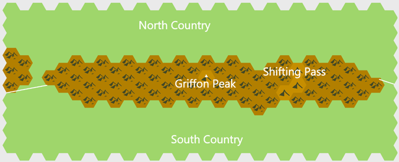
With this in mind, let us return to the Red Range and a very basic hex map of the region.
We already have some idea of where the Red Range is and the elements we’ll want to portray on our map. It’s on the border between two countries, it’s a long, barren mountain range, and it has a location called Griffon Peak with impossible geography, and we want an incentive to go through it rather than around it.
When we start making our map, we know to start with a long, relatively thin range of mountains on a national border. We want an incentive to go over it rather than around it despite how hostile it is, so we’re going to make it take ten times as long to go around the mountains than over it. A two-day trip over the range gives us a width of fewer than 24 miles as mountains are difficult terrain. Meanwhile, the range should be around 400 miles long, so circumventing the mountains will likely take a week or more. When the characters want to move between these two nations, they’ll always have to consider if it’s worth it to go through the range or if they have the time for the safer, more settled route around the mountains.
Now that we have a general outline for the range, we want to populate it. As our big set piece, we want Griffon Peak to be prominent and eye-catching. It should be near the middle of the range, and we want it to stand out. The impossible geography described in the previous article may be hard to capture on a map, but making it visibly larger and clearly labeling it should at least draw the eye. We can also add a major mountain pass, though we don’t need much detail beyond noting its existence. With this in mind, here’s a first pass at what our map might look like:
___
With a regional map in hand, the next article will cover integrating wilderness regions into your setting as a whole.